Thursday, September 29, 2011

Paris park, Parc André Citroën

History and description of the Paris park "Parc André Citroën"

The Parc André Citroen, named after a french industrialist, was built on the former site where was located the Citroën car factory.

The park has an area of 14 ha and was inaugurated in 1992.
In the park, you will find a huge balloon, which is the major attraction. Paris visitors can enjoy the park by taking a ride at 150 meters above Paris.
The park also hosts two huge greenhouses with exotic and Mediterranean plants, as well as several thematic gardens (Jardin Sériel).
Water is omnipresent in the park, with a large canal and water-jets.

Location of the Paris park

The park is located in the XV arrondissement of Paris.

How to get to the Parc André-Citroën

You can use the Paris metro line 8 Balard station.
A second choice can be the Lourmel station (Paris metro line 8).

You can use the Paris rer line C, Boulevard Victor station.

Opening hours of the Paris park

It's a free-admission park, the opening hours are:
at 8am on the week and 9am on the weekend.
The closing time depends on the season:
from 5:45pm (winter) until 9:30pm (between May and august).

Paris park "Parc André-Citroën" map


Friday, September 23, 2011

Paris park, Parc Georges Brassens

History and description of the Paris park "Parc Georges Brassens

Until the end of the XIIIth century, the hamlet Vaugirard housed the vineyard Perichot.
It was replaced, in the XIXth century by markets gardening, and from 1894 by the slaughterhouses.
When the slaughterhouses of Vaugirard was destroyed in 1974, the place became a park. It was designed by the architects Alexandre Ghiulamila, Jean-Michel Milliex and the landscape designer Daniel Colin.
The Parc Georges Brassens (8.7ha (87,000M2)) opened in 1985 and kept some architectural elements from the past:
-like the two sculptures of bulls (Auguste Cain, 1821-1894), located on both sides of the entrance, which originally adorned at the Trocadero garden.


or -the former Auction building of the slaughterhouse of Vaugirard

as well as the "Hall of horses" that was the point of sale of horses for the slaughterhouses.

Location of the Paris park

The parc is located on the XV arrondissement of Paris.

How to get to the of the Parc Georges Brassens

You can use the Paris metro line:
Line 12 Convention station.
Line 13 Porte de vanves station.

Opening hours of the Park

The park opening is 8am during the week and 9am on the week-end.
The closing hours depend on the season:
-between 5:30pm and 9:30pm.

Paris park "Parc Georges Brassens" map


Wednesday, September 21, 2011

The Parc de Bagatelle, Paris park

History and description of the Parc de Bagatelle

The Paris park was built in only 64 days, after a bet between Marie-Antoinette (spouse of Louis XVI, the king) and the comte d'Artois ( who purchased the property in 1775).
It was designed by Belanger and built by Thomas Blaikie, in an Anglo-chinese style, typical of this time.

The park and the Château de Bagatelle barely escaped the destruction of the Revolution. It underwent multiple transformations, after this period.
In 1905, it was purchased by the City of Paris, and Jean-Claude Nicolas Forestier was in charge of its restoration.
Each year, since 1907 "the rose bed of Bagatelle", an international competition of roses occurs, thanks to Jean-Claude Nicolas Forestier.

Today, the Parc de bagatelle is an 24ha park (240,900 m2, opened in 1777.
From may to september, 10000 rosebushes offer a wonderful spectacles.
The park is closed to the Jardin d'acclimatation de Paris and the Jardin des serres d'Auteuil.

From the booth it's possible to see a part of the valley of the Seine and from the courtyard, in the left of the castle, we may see the towers of the Defense.

Chinese Pagoda in the square

Location of the Parc de bagatelle

The park is located in the 16th arrondissement of Paris.
The principal entrance is: Route de Sèvres-à-Neuilly, Bois de Boulogne, Paris 16ème

How to get to the Paris park

You can use the Paris metro line, the closest is the
Metro line 1 Pont de Neuilly station , then bus 43 direction "Place de Bagatelle", arrêt "Place de Bagatelle" or walk alongside the "avenue de Longchamps".
Metro line 1 Porte Maillot station, then bus No. 244.

Entrance fee

It's a free-admission park except when there are temporary exhibitions (3€).

Paris park "Parc de Bagatelle" map


Sunday, September 18, 2011

The Parc de la Butte-du-Chapeau-Rouge, Paris park

History and description of the Parc de la Butte-du-Chapeau-Rouge

In the 19th century, the Paris park was part of the extensive network of quarries of gypsum, which extended to the Parc des Buttes-Chaumont.
After the First World War, the hill escaped extensive development work, which followed the demolition of the Thiers wall (was the last defensive wall around Paris and was destroyed between 1919 and 1929).

The Parc de la Butte-du-Chapeau-Rouge has an area of 4.7 hectares (47.000 m2) and opened to the public in 1939. It offers a wonderful clear view of the North-east of Paris.
The architecture is a neo-classic style, typical of the 30's, was designed by Leon Azema.

Inside the parrk there are 3 notable sculptures:
At the main entrance standing in a fountain, the statue "Eve" created by Raymond Couvègnes (1938).

A marble sculpture “Both” created by sculptor Eugene Dodeigne (1990)

"Two Women and a Child" created by Pierre Traverse (1938).

Location of the Parc de la Butte-du-Chapeau-Rouge

The parc is located in the XIX arrondissement of Paris.

How to get to the of the Paris park

You can use the Paris metro line 7bis, Pré Saint Gervais station (closest).
You can stop at the Danube station line 7bis, also.

Entrance fee and opening hours

It's a free admission park, the opening hours are 8am during the week, 9am on the weekend.

The Paris park "Parc de la Butte-du-Chapeau-Rouge" map


Friday, September 16, 2011

The square Sarah Bernhardt, Paris park

History and description of the Square Sarah Bernhardt

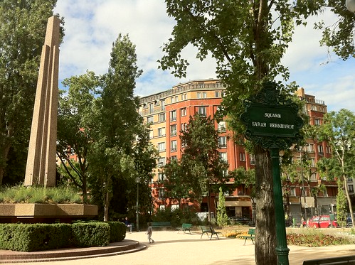
The Paris park was name after the actress Sarah Bernhardt (la Dame aux Camélias, La Tosca, Jeanne d'Arc...); It was built in 1936, for some part of it on a former gas plant.

Today there are around 200 trees with 50 different species (Japanese sophoras, aucubas, forsythias, lindens, sequoias...) for a 12 874 m² area (1,28 ha).

The Obelisk in the square Sarah Bernhardt
Square Sarah Bernhardt à Paris
Creative commons

The obelisk is typical of the 30s. Around it, there are the heathland plants and perennials, and behind a large red brick shelter.

Location of the Paris park

The square is located in the XXth arrondissement of Paris.

How to get to the square Sarah Bernhardt

You can use the Paris metro line 9, Buzenval station.

Paris park square Sarah Bernhardt map


Thursday, September 15, 2011

Square Edouard-Vaillant, Paris park

History and description of the Square Edouard-Vaillant

This Paris park was built in 1879, named after the surgeon Jacques-René Tenon (1724-1816) "square tenon", it was renamed "square Edouard-vaillant", named after a politician.
The square has an area of 8,085m² (0.8ha) and is located between the city hall and the hospital Tenon.

Bandstand in the square


Creative commons

Léon Gambetta statue


Creative commons

This large stone statue is the work of Jean-Paul Aube and Louis-Charles Boileau.

In addition to the statue and the bandstand, there is a nice winter garden, miniature replica of the large greenhouses of the Second Empire.

Location of the square

The square is located in the XXth arrondissement of Paris.

How to get to the of the Square Edouard-Vaillant

To go to the Paris park, you can use the Paris metro line 3 or Paris metro line 3bis, Gambetta station.

Opening hours

The Paris square opens at 8am during the week and 9am on weekend and public holidays.
The closing depends on the season and month of the year.

The Paris park "Square Edouard-Vaillant" map


Wednesday, September 14, 2011

Jardin naturel, Paris garden

Description of the Jardin Naturel

The Paris garden "Jardin Naturel" recreates the natural environment of the Ile-de-France region (Paris + suburb).It was created in 1995.
This garden of 6300 square meters (0.63ha) houses native plants, often unrecognized.
The City uses maintains a balance to save those plants more and more rare, by using some gardening technique (compliance with the cycles of vegetation, conservation of litter sizes kept to a minimum, chemical treatments excluded, regular mowing removed).

A stairway leads to the upper promenade, with a terrace revealing a panoramic view of the garden. At the foot of the staircase, there are some large limestone. They were chosen in memory of those extracted from quarries here in the 19th century.
On the terrace, next to the guard booth, an open shelter houses temporary exhibitions.

Location of the Paris garden

The Paris garden is located "rue de la réunion" in the XXth arrondissement of Paris.
It's close to the "Cimetière du Père Lachaise".

How to get to the Jardin Naturel

To go to the Jardin Naturel, you can use the Paris metro line 2 Alexandre Dumas station.

Entrance fee and opening hours

It's a free admission garden.
The opening hours are:
-8am on the week
-9am on the weekend and public holidays.
The closing hours depend on the season.

The Paris Garden "Jardin Naturel map


Monday, September 12, 2011

Paris Square (the square séverine)

Description of the Paris square, the square séverine

The square Séverine, created in 1933, has an area of 23,537m2 (2.35ha).
It's is a pretty steep park which houses a wide variety of trees as the weeping Elm, European nettle tree, copper beech, Judas tree, ginkgo, tulip tree...
The square is located in the XXth arrondissement of Paris. It is elevated, with sloping lawns and green terraces.
It has several recreational areas and games for all ages such as a playground for children, a sandpit, a skatepark, table tennis, a sliding area and an auditorium...

How to get to the square Séverine

To go to the Paris square, you can go by the Paris metro line 3, Porte de Bagnolet station.

Opening hours

The square opens at 9h30am.
The closing hours depends on the season, it can be between 5pm (winter) to 8h30pm (from May to August).

The Paris square Séverine map


Jardin Tino Rossi

Description and History of the Jardin Tino Rossi

During the XVIth and XVIIth centuries, Parisians was gathering on the shore of the "Quai Saint-bernard" to bathe.
In 1861, there were 7 cold thermal baths and 4 hot thermal baths on the Seine, and 107 thermal baths in the capital.

Between 1975 and 1980 the Quai Saint-Bernard, was transformed in a garden. Since 1980, the garden houses the "Musée de la Sculpture en Plein Air" (the Museum of outdoor sculpture). The Jardin is alongside the Seine and the quai Saint-Bernard and is a 3.16ha park.
To access the Jardin Tino Rossi you need to use the stairs, in front of the Arab institute. Those stairs lead towards the "Musée de la Sculpture en Plein Air". Several sculptures of contemporary sculptors are presented such as Brancusi, César, Schoffer...in the museum.

From the garden there is a wonderful view of "the cathedral of Notre-Dame-de Paris", l’"Ile Saint-Louis" and the "Seine"; it offers a pleasant walk and various leisure activities.

How to go to the Jardin Tino Rossi

To go to the park you can use the Paris metro line 7 ou Paris metro line 10 Jussieu station .

Another alternative is to take the Paris metro line 5, the Paris metro line 10, Gare d'austerlitz station .

Opening hours

The garden is open 365 days a year.

the Jardin Tino Rossi map


Wednesday, September 7, 2011

Parc Clichy-Batignolles - Martin Luther King, Paris park

The Parc Clichy-Batignolles-Martin Luther King is a greenspace of 4.3ha. This Paris park was created by the Landscape architect Jacqueline Osty with her team, since 2004.
It opened in 2007 for the public.
The goal is to reach a 10h park, which is schedule for later.

Clichy-Batignolles Park comes around three themes: seasons, sport and water.
The "jardin du rail" at the entrance of the Park, rue Cardinet, highlights the "sport" with different activities connected to this theme.
In the middle of the park a wind power machine dominate the scene.

The bassin biotope of the Paris Park
The biotope basin is a 3000 square meters space. This pound houses aquatic plants and flowers on shore, like lilies, iris, reed...
It is located alongside the "Petite Ceinture", its purpose is to purify the water from the Seine before being use for watering.

Location of the Paris park

The Parc Clichy-Batignolles - Martin Luther King is located in the 17th arrondissement of Paris.

How to get to the Park

You can use the Paris metro line.
The Paris metro line 13 brochant station is the closest.

Parc Clichy-Batignolles - Martin Luther King map


Monday, September 5, 2011

Square des batignolles

History and description of the Square des Batignolles

In the beginning of the XIXth century, the hamlet of Batignolles became a nice village when rich merchants built their second homes.

Under Napoleon III, the village of Batignolles was attached to the City of Paris in 1860. In 1862, the Square des Batignolles was created by Alphand.
The Baron haussmann (with a team composed by the engineer Alphand assisted by the architect Davioud, the horticulturist Barillet-Deschamps and the engineer Darcel) was in charged of the building.

The Square is a 16,615 square meters park, it's slightly hilly and it's one of the largest park in the 17th arrondissement of Paris.
It houses:
-Magnificent trees, especially plane trees planted in 1840 and 1880 and a giant sequioa
-A rich flora and fauna...
-A waterfall coming out of the rocks and flowing into a stream and ended on a rounded pond.
-A black stone sculpture of Louis Volvic Monard "Vultures" (1930) in the park:
Creative commons
-A bust of the poet Leon Dierx (1838-1912), by Bony de Lavergne (created in 1932).
-The square offers many activities for children, like the other Paris parks.
-In 1996, a greenhouse was installed in the square located on the side of the Place Charles Fillion.

Location of the square des Batignolles

The Square des Batignolles is located in the 17th arrondissement of Paris.

How to get to the square

To go to the square des batignolles, you can use the Paris metro line:
-Line 13 Brochant station (it's the closest).

Entrance fee and opening hours

It's a free admission park.

Square des batignolles map


Related Posts Plugin for WordPress, Blogger...